
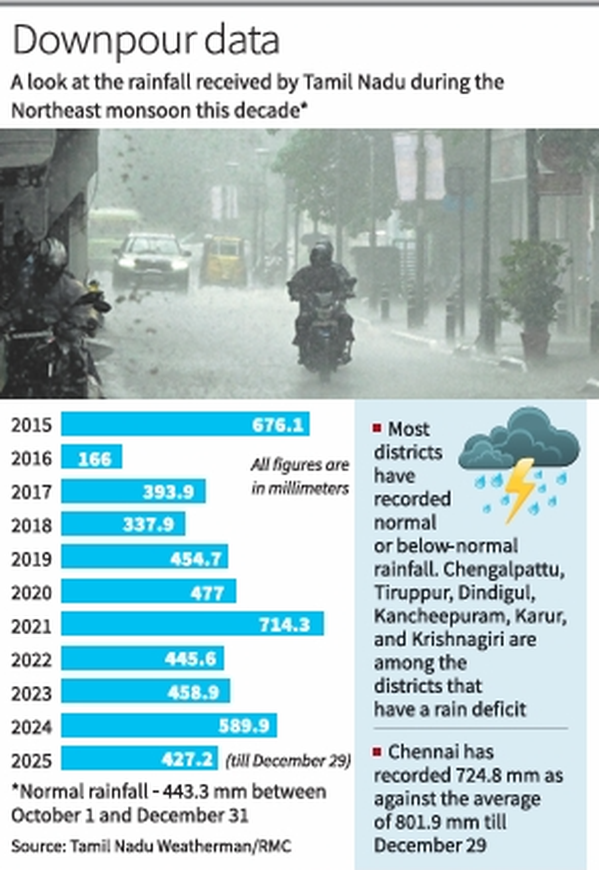
After maintaining a six-year streak of normal or surplus rainfall since 2019, Tamil Nadu is likely to record slightly below-normal rainfall during the Northeast monsoon this year, with scattered rainfall marking the final two days before the official end of the season.
As the monsoon’s lull phase continues over the State, dry weather has prolonged over most parts, and the State did not record any rainfall on Monday too. Tamil Nadu has so far recorded 42.7 cm, which is 3% lower than the seasonal average of 43.8 cm. The India Meteorological Department (IMD) considers deficit or surplus rainfall up to 19% as normal.
According to the Regional Meteorological Centre (RMC), a trough in the Easterlies running over the southeast Bay of Bengal would influence mild rainfall particularly over south Tamil Nadu and districts along Western Ghats on Tuesday. Isolated rainfall may occur over the State until January 4.
B. Amudha, Head (Additional in-charge), RMC, said the monsoon is in a weak and dry phase. Isolated showers of light to moderate intensity are expected over the next few days. While IMD considers December 31 as the official end of the NE monsoon, weather conditions are being monitored to declare its withdrawal from the region. The monsoon rainfall has spilled over into January in previous years.
In its extended weather outlook, the RMC forecast that above normal rainfall is likely over north coastal Tamil Nadu, Puducherry, and Karaikal area, and near-normal to below-normal rainfall may occur in the remaining parts between January 2 and January 8.
Weather bloggers noted that Tamil Nadu experienced several dry days this monsoon. The absence of a Madden–Julian Oscillation, a large-scale eastward moving band that plays a crucial part in enhancing cloud formation and rainfall, over the Indian Ocean during November and December was the major reason behind the prolonged dry spell, they said.
R. Pradeep John, who runs a weather blog ‘Tamil Nadu Weatherman’, said November alone recorded nearly 20 dry days across the State, well above the seasonal average. Though an Equatorial Rossby wave, an atmospheric wave pattern that influences tropical weather patterns, aided rainfall through Cyclone Ditwah during early December, it was insufficient to revive widespread rainfall across the state.
With high pressure systems dominating the region, cold and dry weather is prevailing across the State. Chennai’s five-year streak of surplus rainfall since 2020 has come to an end this year, he said.
The RMC has forecast minimum temperature may drop by two or three degrees below average at isolated pockets over Tamil Nadu, Puducherry, and Karaikal till Wednesday. A ground frost warning is likely to continue for higher ranges of Kodaikanal and Nilgiris district on Tuesday.
Published – December 30, 2025 05:30 am IST